LEGAL DESCRIPTIONS
LEGAL SUMMARY of DAYTON SCHOOL DISTRICT #38
Dayton School District #38 description: Beginning at a point where the north reservation line intersects the west shore of Flathead Lake; thence west about five and one-half miles through the center line of Section 32, Township 25, Range 21; thence south to the northeast corner of the southeast quarter of the southwest quarter of Section 32, Township 25, Range 21; thence west one-quarter mile; thence north to the reservation line; thence west on said line to the northwest corner of Section 31, Township 25, Range 22; thence south to the north boundary line of township 24; thence east to the northwest corner of Section 6, Township 24, Range 22; thence south three miles to the southwest corner of Section 18, same township and range; thence east three miles; thence north two miles to the northwest corner of Section 10; thence east four miles; thence south one mile to the southwest corner of Section 8, Township 24, Range 21; thence east one mile; thence south about one mile to the lake shore; thence following the lake shore to the place of beginning and also including Wild Horse and Wild Goose Islands, the original boundaries of District 38 being altered by the creation of Districts 40 (Battle Butte), 42 (Loon Lake), 64 (Matt), and 22 (Elmo).
Transfer from this district to Big Arm School District No. 65: Lot 1, Section 24 and Lot 1, Section 25, Township 24 N, Range 21 W of Wild Goose Island.
Consolidated to West Shore High School District No. 1, February 23, 1949. Annexed to Polson High School District No. 23, July 3, 1952.
Annexed to Proctor School District No. 24, February 27, 1954: Sections 31, 32, and 33, Township 25 N, Range 21 W.
DAYTON SCHOOL DISTRICT #36 began March 20, 1959. The change of district number from #38 to #36 was due to the confusion of Bigfork School District No. 38J, a joint district of both Flathead and Lake Counties.
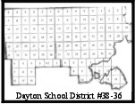 Dayton School District #36 description as of 1961: Beginning at the meander corner between fractional Sections 16 and 17, Township 24 N, Range 21 W; thence north a fractional part of a mile to the northwest corner of Section 16; thence west 1 mile; thence north 1 mile; thence west four miles to the northeast corner of Section 9, Township 24 N, Range 22 W; thence south 2 miles; thence west 3 miles to the southwest corner of Section 18, Township 24 N, Range 22 W; thence north 3 miles to the northeast corner of Section 6, Township 24 N, Range 22 W; thence west a fractional part of a miles to the southwest corner of Section 31, Township 25 N, Range 22 W; thence north to a point on the west boundary of Section 31 where the Flathead Indian Reservation boundary intersects therewith; thence east along said boundary 6 miles; thence south a fractional part of a mile to the southeast corner of Section 36, Township 24 N, Range 22 W; thence east 3 miles to the southeast corner of Section 33, Township 25 N, Range 21 W; thence north a fractional part of a mile to a point where the Flathead Indian Reservation boundary intersects with the east boundary of Section 33; thence east along said boundary approximately 4.1 miles to a point where said boundary intersects with the meander line of Flathead Lake; thence along said meander line to the point of beginning. This includes Wild Horse and Cromwell Islands.
Letter February 8, 1972: State Superintendent approved Dayton School District No. 36 as a portion of Polson High School District No. 23.
UPPER WEST SHORE ELEMENTARY SCHOOL DISTRICT #33 was formed through consolidation of School Districts 24 (Proctor), 36 (Dayton), and 41 (Rollins), July 1, 1972.
District #33 description as of July 1, 1972: Beginning at the meander corner common to Section 4, Township 25 N, Range 20 W, P.M., and Section 33, Township 26 N, Range 20 W, P.M., then along the boundary between Township 25 N and Township 26 N for fourteen and about one-fourth miles to the Northwest Corner of Section 6, Township 25 N, Range 22 W, P.M.; thence south six miles to the southwest corner of Section 31, Township 25 N, Range 22 W, P.M.; thence east sixty-five one-hundredths of a mile; thence south three miles to the southwest corner of Section 18, Township 24 N, Range 22 W, P.M.; thence east three miles; thence north two miles; thence east four miles to the northeast corner of Section 7, Township 24 N, Range 21 W, P.M.; thence south one mile; thence east one mile; thence south about seventy-two one-hundredths of a mile to the meander corner common to Section 16 and Section 17,
Township 24 N, Range 21 W, P.M., on the shoreline of Flathead Lake; thence easterly and northerly along the shoreline of Flathead Lake to the place of beginning at the meander corner common to Section 4, Township 25 N, Range 20 W, P.M.. Also: Wildhorse Island and Cromwells Island in Township 24 N, Range 20 W and Township 24 N, Range 21 W.
Letter November 17, 1975: State Superintendent recognizes Upper West Shore School District No. 33 as a portion of Polson High School District No. 23.